STORM WATCH: Parade of winter storms give 3 shots of snow through the weekend and next week in New Jersey
3-6 inches of snow is expected across parts of New Jersey Saturday into Sunday with more snow for Tue-Wed and then maybe again by Friday.
Share:
More Stories
1:55

STORM WATCH: A plowable snow will hit the Hudson Valley this weekend
in 1,405m2:45

STORM WATCH: Snow, ice mix expected across Brooklyn for Saturday night
3h ago2:26

STORM WATCH: Snow, ice mix expected across the Bronx for Saturday night
3h ago2:12

STORM WATCH: Storm to bring 3-6 inches of snow starting Saturday night for Long Island
3h ago2:16

STORM WATCH: 4-6 inches of snow expected Saturday, up to 9 inches possible in spots north of I-84
4h ago1:02

Thunderbolt 12: Snow, freezing rain creates messy morning commute
yesterday1:55
STORM WATCH: A plowable snow will hit the Hudson Valley this weekend
in 1,405m2:45
STORM WATCH: Snow, ice mix expected across Brooklyn for Saturday night
3h ago2:26
STORM WATCH: Snow, ice mix expected across the Bronx for Saturday night
3h ago2:12
STORM WATCH: Storm to bring 3-6 inches of snow starting Saturday night for Long Island
3h ago2:16
STORM WATCH: 4-6 inches of snow expected Saturday, up to 9 inches possible in spots north of I-84
4h ago1:02
Thunderbolt 12: Snow, freezing rain creates messy morning commute
yesterdayA winter storm warning has been issued for western Passaic and western Bergen counties ahead of this weekend's storm.
A winter storm is set to deliver 3-6 inches of snow across northern New Jersey with up to 9 inches possible for Sussex and northern Passaic counties on Saturday night into early Sunday. The storm starts after 5 p.m. on Saturday with snow lasting through the overnight. A sharp cutoff of snow totaling 3-6 inches and 1-3 inches will take place in central Monmouth, southern Middlesex, and all of Mercer counties where snow accumulates at first, but a mix of wet snow/sleet/rain moves through to compact any snowfall by Sunday morning.


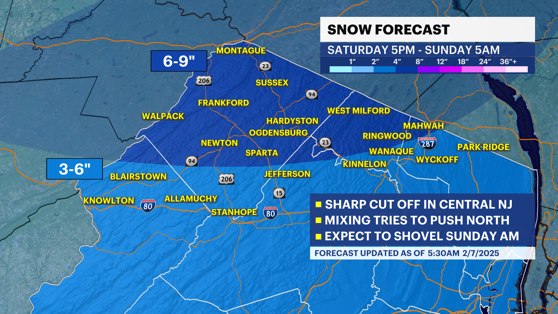

Lingering flurries push through Bergen County until about 8 a.m. before wrapping up fully. The sun emerges on Sunday afternoon with the temperature rebounding to the mid-40s. The snow melts but if not cleaned up early, it will be heavy-weight snow. Please be careful shoveling. Monday looks good with a mix of sun and clouds and fair conditions as well. Another round of snow is expected Tuesday afternoon and night into Wednesday.
Most of this snow looks to it will dive to the south, giving South Jersey a run for accumulating snow. The location of the largest amount of snowfall is still quite uncertain as this storm is taking and north vs south scenario track. We will know more after the weekend storm wraps up on Sunday. We are also watching Thursday into Friday for rain and snow.
More from News 12
1:55
STORM WATCH: A plowable snow will hit the Hudson Valley this weekend

Snow emergency declared for Upper Nyack this weekend
2:45
STORM WATCH: Snow, ice mix expected across Brooklyn for Saturday night
2:26
STORM WATCH: Snow, ice mix expected across the Bronx for Saturday night
2:12
STORM WATCH: Storm to bring 3-6 inches of snow starting Saturday night for Long Island
2:16